← Home · Laboratory

Grain Size Analysis (Sieve + Hydrometer) in Lethbridge

Together, we solve the challenges of tomorrow.

LEARN MORE →

Lethbridge sits perched above the Oldman River valley, a landscape carved by glacial meltwater that left behind a complex patchwork of till, lacustrine clays, and alluvial sands. When the high-level bridge went up in 1909, engineers understood something we still contend with today: the ground beneath this city changes fast over short distances. A trench on the west side can hit stiff till within a meter, while a site three blocks east on the floodplain uncovers silts that a shovel slices through like butter. That variability makes grain size analysis essential for any project here—whether you are designing a stormwater infiltration basin on the north side or verifying subgrade for a commercial slab near Scenic Drive. Getting the gradation curve right means understanding drainage potential, frost susceptibility, and compaction behavior before the first bucket hits the dirt. In our experience, skipping this step in southern Alberta’s glacial terrain leads to surprises that cost far more than the testing itself. We run the full suite—sieve stack plus hydrometer—so the fine fraction does not get ignored, and we cross-reference results with the regional drift stratigraphy mapped by the Geological Survey of Canada.

A sieve-only gradation in Lethbridge’s lacustrine clays can miss 40% of the soil’s mass—that hidden fraction dictates frost design and drainage performance.

Process and scope

The surficial geology under Lethbridge is dominated by Glacial Lake Lethbridge sediments and till of the Laurentide ice advance, which means fines content can swing from 15% to over 70% inside a single subdivision. That is why we never run just a dry sieve and call it done. The hydrometer step—following ASTM D7928 in a temperature-controlled settling column—captures the silt and clay fraction that controls Atterberg limits and frost heave potential in our climate. A typical sample from the Marie Reine area might yield a well-graded sand with gravel lenses, while material near the coulee slopes often carries enough plastic fines to trigger slope drainage concerns when we evaluate it alongside a slope stability assessment. Our technicians wash every sample through the #200 sieve before the hydrometer run because oven-drying a clayey silt without washing locks fines onto the coarse grains and skews the whole curve. We report a full particle size distribution with D10, D30, D60, coefficient of uniformity, and coefficient of curvature so your geotechnical engineer can assess filter compatibility, internal stability, or suitability for engineered fill without requesting extra runs.
Grain Size Analysis (Sieve + Hydrometer) in Lethbridge
Technical reference image — Lethbridge

Local ground factors

Lethbridge winters do not flirt with freezing—they commit. With over 110 days below 0°C annually and a frost penetration depth codified in the Alberta Building Code at 1.8 meters in exposed areas, the silt fraction in your subgrade becomes a liability if nobody measured it. Fine-grained soils with more than 10% passing the #200 sieve can wick moisture into the frost line and heave with enough force to crack a slab-on-grade or displace a shallow footing. The chinook winds complicate things further: rapid thaw cycles turn the upper few inches into soup if drainage is poor, and drainage is governed directly by the grain size distribution. A gap-graded sand with silt lenses might look competent in the summer but will trap water at the interface come spring. We also watch for the clay fraction below 2 microns—even modest percentages of smectite-group minerals, common in the Bearpaw Formation that outcrops along the river valley, can produce shrink-swell behavior that a gradation test alone will flag through the plasticity correlation. That is why we recommend pairing the grain size analysis with Atterberg limits whenever the hydrometer shows more than 12% clay-sized particles.

Need a geotechnical assessment?

Reply within 24h.

Email: info@geotechnicalengineering.xyz

Typical values

ParameterTypical value
Test Method (Coarse)ASTM D6913 / C136 (Sieve Analysis)
Test Method (Fine)ASTM D7928 (Hydrometer Analysis)
Minimum Sample Mass500 g for sands; 200 g for silts/clays
Sieve Range75 mm to 75 µm (#200 sieve)
Hydrometer Range75 µm to approximately 0.5 µm
Dispersing AgentSodium hexametaphosphate per ASTM D7928
ReportingSemi-log gradation curve + D10/D30/D60/Cu/Cc

Complementary services

01

Combined Sieve & Hydrometer Package

Complete ASTM D6913 + D7928 suite from a single split sample. Suitable for geotechnical characterization, filter design, and fill specification verification.

02

Washed Sieve Analysis (Coarse-Only)

Mechanical sieving with wet washing through the #200 sieve. Ideal for concrete aggregate or asphalt mix gradation checks where fines content is secondary.

03

Hydrometer-Only Fine Fraction Analysis

Sedimentation test for soils passing the #10 or #40 sieve. Used when the coarse fraction is already characterized and only the silt-clay distribution is needed.

Relevant standards

ASTM D6913/D6913M – Standard Test Methods for Particle-Size Distribution (Gradation) of Soils Using Sieve Analysis, ASTM D7928 – Standard Test Method for Particle-Size Distribution (Gradation) of Fine-Grained Soils Using the Sedimentation (Hydrometer) Analysis, ASTM D422 (withdrawn, still referenced) – Standard Test Method for Particle-Size Analysis of Soils, CSA A23.3 (contextual for concrete aggregate gradation requirements in Canadian construction)

Quick answers

How much does a grain size analysis cost in Lethbridge?

A combined sieve and hydrometer analysis typically runs between CA$120 and CA$250 per sample, depending on whether you need a rush turnaround and how much gravel fraction requires extra sieving. Samples with high organic content or unusual dispersant requirements may fall at the upper end of that range.

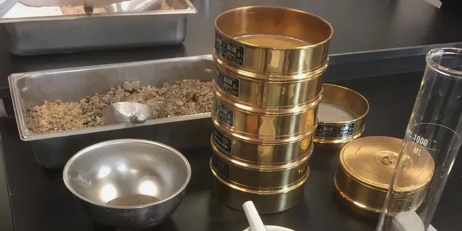
How long does the hydrometer test take compared to the sieve analysis?

The sieve portion can be completed in one day, but the hydrometer analysis requires a minimum of 24 hours of sedimentation readings and often extends to 48 hours for the full curve. We usually report combined results within three to four business days from sample receipt.

Do I need the hydrometer if my soil looks sandy?

In the Lethbridge area, visual classification is unreliable. Many sands here carry a significant silt fraction from glacial grinding. If the material coats your fingers dusty when dry or feels smooth when wet, the hydrometer will quantify the fines that control drainage and frost behavior—skipping it is a gamble.

What sample mass do you need for a full analysis?

We request at least 500 grams of air-dried material for a combined test. For gravelly soils with particles larger than 19 mm, we prefer a larger bag—around 2 kg—so the coarse fraction is representative. Samples should be sealed in a plastic bag immediately after extraction to preserve natural moisture.

Location and service area

We serve projects in Lethbridge and surrounding areas. More info.

View larger map