← Home · Geophysics

Electrical Resistivity Testing & Vertical Electrical Sounding (VES) in Lethbridge

Together, we solve the challenges of tomorrow.

LEARN MORE →

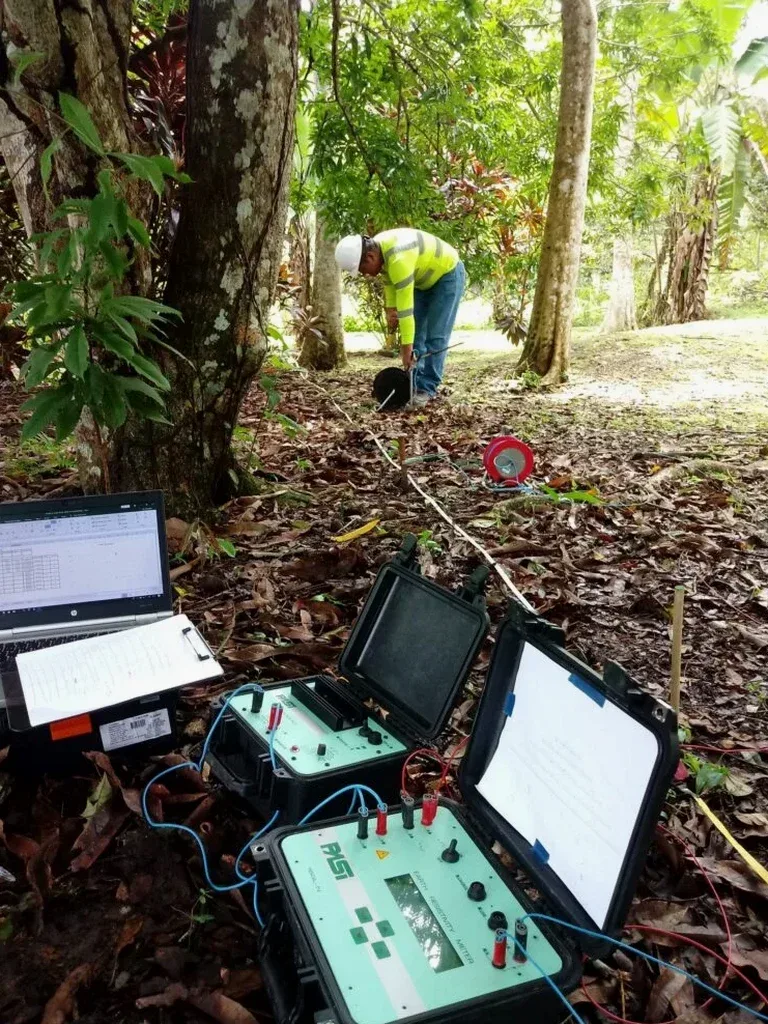
The Syscal Pro resistivity meter is the primary tool deployed for vertical electrical sounding across Lethbridge terrain. Electrode spreads of 100 to 400 meters push controlled DC current into the subsurface, measuring potential differences that reveal true stratigraphic layering beneath the prairie surface. Lethbridge lies within a semi-arid region averaging less than 380 mm of precipitation annually, which means surficial soils often exhibit high contact resistance. The field crew addresses this by saturating electrode positions with bentonite-water slurry before each measurement cycle. A single VES station can map resistivity contrasts down to depths exceeding 80 meters, capturing the transition from glacial till into the Bearpaw Formation shale that underlies much of the city’s river valley. Combining these profiles with test pit logging provides ground-truth calibration where the Oldman River has carved exposed stratigraphic sections.

Vertical electrical sounding in Lethbridge’s glacial till reveals resistivity contrasts that directly correlate with grain-size changes—critical for mapping aquifer lenses and clay barriers before construction begins.

Process and scope

The subsurface around Lethbridge is dominated by thick sequences of Pleistocene glacial drift overlying Cretaceous bedrock. Till units interbedded with outwash sands and silts create complex resistivity signatures that require careful interpretation. Vertical electrical sounding cuts through this ambiguity by measuring apparent resistivity at progressively larger electrode spacings—effectively sampling deeper with each expansion cycle. The resulting curve, inverted with software like RES2DINV, identifies water-bearing sand lenses, clay-rich till layers, and the depth to competent shale. For projects near the coulee slopes where groundwater seepage affects stability, integrating resistivity data with slope stability analysis clarifies the hydrogeological model before excavation begins. In areas slated for infrastructure expansion, the method also helps distinguish uncontaminated native soils from historic fill, and pairing it with MASW surveys delivers a combined geophysical dataset that maps both stiffness and moisture conditions across the site.
Electrical Resistivity Testing & Vertical Electrical Sounding (VES) in Lethbridge
Technical reference image — Lethbridge

Local ground factors

Lethbridge’s urban footprint expanded rapidly after the Canadian Pacific Railway reached the river valley in 1885, pushing development onto glaciolacustrine deposits and colluvium along the coulee edges. These materials contain perched groundwater tables that fluctuate seasonally and can saturate foundation zones undetected. A resistivity survey—especially multi-electrode profiling or a grid of VES stations—identifies low-resistivity anomalies indicative of saturated silts or clay seams before earthworks mobilize. Missed water-bearing layers frequently lead to subgrade softening, differential settlement in shallow footings, and long-term pavement distress on arterial roads like Mayor Magrath Drive. In the industrial park areas north of the CPR yard, variable fill thickness and buried debris create additional uncertainty; electrical imaging helps isolate these zones so that remediation costs don’t surprise the project budget halfway through excavation.

Need a geotechnical assessment?

Reply within 24h.

Email: info@geotechnicalengineering.xyz

Explanatory video

Typical values

ParameterTypical value
Array configurationSchlumberger, Wenner, or dipole-dipole
Typical electrode spreadAB/2 max 150–200 m (depth penetration ~50–70 m)
Measurement range0.1 Ωm to 100,000 Ωm
Injection currentUp to 500 mA, automatic voltage adjustment
Standard referenceASTM D6431-18; CSA A23.3 context
Data inversion softwareRES2DINV / EarthImager 2D
Output deliverablesResistivity pseudo-section, interpreted stratigraphic cross-section, VES curve plots

Complementary services

01

Vertical Electrical Sounding for Stratigraphic Profiling

Schlumberger-array VES stations positioned at 50 to 100-metre intervals map the depth to bedrock and identify major lithological boundaries. Each sounding generates a resistivity-versus-depth curve that pinpoints sand aquifers, till layers, and the Bearpaw shale contact.

02

2D Electrical Resistivity Tomography for Cross-Sectional Imaging

Multi-electrode cables with 48 or 72 take-outs produce continuous resistivity pseudo-sections along transects. This method resolves lateral changes in soil moisture, buried channel deposits, and fracture zones in bedrock—essential for pipeline routing and slope assessment.

03

Groundwater and Contamination Mapping

Low-resistivity zones correlate with dissolved salts, leachate plumes, or elevated groundwater conductivity. Grid-based resistivity surveys delineate contaminant migration pathways through the glacial drift, supporting Phase II environmental site assessments under Alberta Tier 1 guidelines.

Relevant standards

ASTM D6431-18 Standard Guide for Using the Direct Current Resistivity Method for Subsurface Site Characterization, CSA A23.3 Design of Concrete Structures (context for foundation design requiring subsurface resistivity input), NBCC 2020 National Building Code of Canada (Section 4.2 geotechnical site investigation requirements), Alberta Transportation Geotechnical Design Manual (geophysical survey acceptance standards)

Quick answers

How much does a vertical electrical sounding survey cost in Lethbridge?

Budgeting for VES work in southern Alberta typically falls between CA$760 and CA$1,610 per sounding station, depending on electrode spread length, terrain access, and the number of stations required. A full day of 2D resistivity profiling with a multi-electrode system and technician is generally priced higher due to equipment and processing time.

What depth can a VES survey reach in the Lethbridge area?

Depth penetration depends on the maximum current electrode half-spacing (AB/2). With a 200-metre AB/2 spread—common in Lethbridge’s glacial terrain—the effective investigation depth reaches approximately 60 to 70 metres. Greater depths are achievable in dry, high-resistivity overburden, though signal strength must be monitored continuously.

Does electrical resistivity testing work during winter in Lethbridge?

Yes, but frozen ground presents high contact resistance at the surface. The field team uses bentonite mud around each electrode stake and may pre-drill through the frozen crust to ensure adequate current injection. Winter surveys are routinely conducted for projects on tight schedules, though interpretation accounts for the resistivity spike caused by ice in near-surface pores.

Location and service area

We serve projects in Lethbridge and surrounding areas.

View larger map